User interface
In the User Interface section, user can specify various map settings, user interface language, units of measurement, time zone, etc.
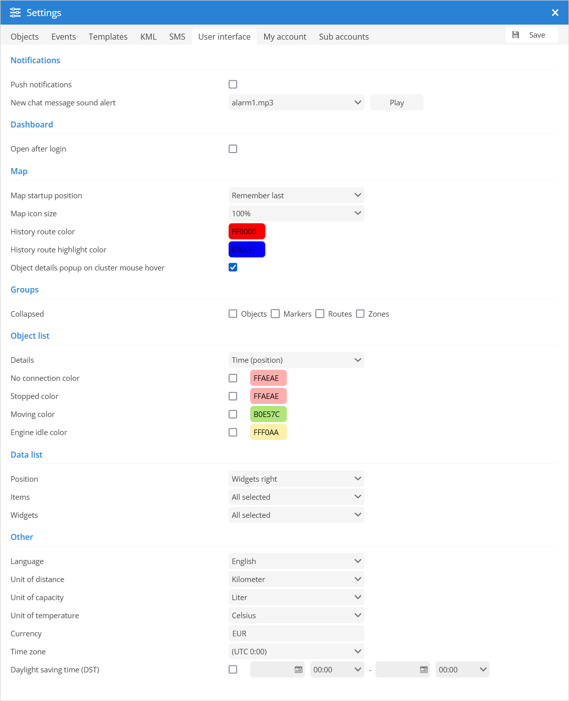
- Notifications
Push notifications - enables/disables browser push notifications.
New chat message sound alert - user can select which sound will be played when notification is received.
- Dashboard
Open after login - enables/disables opening the dashboard after login.
- Map
Map startup position - every time you log in to the system interface, the map will be in the same place where you left it (for this option the browser must accept cookies):
Default - default software settings.
Remember last - every time you login to system user interface map will be in the same place you left it (this option requires browser to accept cookies).
Fit objects - map will be automatically zoomed so all objects will be seen in view port.
Map icon size - allows the user to adjust the size of object icons on the map.
History route color - color of the route displayed in the history.
History route highlight color - color of the highlighted route displayed in the history.
Object details popup on cluster mouse hover - the object details are displayed in a popup dialog when the mouse pointer is over a cluster.
- Groups
Collapsed - allows objects, markers, routes or/and zone groups to be opened collapsed by default.
- Object list
Details - allows to set which object details will be shown in object list:
Time (position) - The object list shows the time of the last known GPS location.
Time (server) - The object list shows the last communication time between the GPS device and the server.
Status - In the object list GPS the device status is displayed: moving, stopped, idle or offline.
No connection color - set color of objects in the object list when the connection between object and server is lost.
Stopped color - set color of objects in object list when object stops.
Moving color - set color of objects in object list when object moves.
Engine idle color - set the color of the objects in the object list, if the Object Engine IDLE.
- Data list
Position - set the position of the widgets in the bottom panel (left or right).
Items - select data items to be displayed in the bottom panel.
Widgets - select widgets to be displayed in the bottom panel.
- Other
Language - select the language of the user interface.
Unit of distance - choose miles or kilometers as unit of distance measurement.
Unit of capacity - choose liters or gallons as the unit of measure for capacity.
Unit of temperature – choose Celsius or Fahrenheit as the temperature measurement unit.
Currency - set the currency that appears in the fuel consumption costs.
Time zone - set the time zone of the place where the device is operated. Specify your time zone accurately, as all time values will be displayed according to the selected time zone. Make sure that the time zone of your GPS device is set to 0 UTC.
Daylight saving time (DST) - the changeover to daylight saving time means that clocks are advanced by one hour during the summer months so that evening light lasts an hour longer, while normal sunrise times are sacrificed. Typically, in regions with Daylight Saving Time, clocks are set forward one hour just before the start of spring and reset to standard time in the fall. Set the start and end dates when the additional time is added to the time zone.